-
-


-
Wall Color
in
Uncheck to hide the white line Check to show the white line -
-
.


Frame
Room
Gallery
Historic Map : Mitchell Map of England, Version 2, 1854, Vintage Wall Art
Historic Map : Mitchell Map of England, Version 2, 1854, Vintage Wall Art
Note: Sold out or unavailable
Couldn't load pickup availability
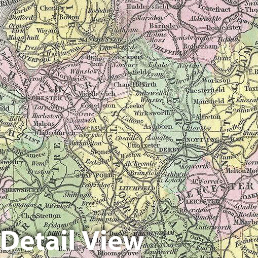
This is a fine example of Thomas Cowperthwait and S. A. Mitchell's 1854 map of England. It covers all of England from Northumberland in the north to Cornwall in the south. Two insets in the upper left and right quadrants depict the environs of Liverpool and London, respectively. A small inset of the Scilly Islands is featured in the lower left quadrant. The whole is engraved in Mitchell's distinctive style with green border work and vivid pastels. Political and topographical features are noted and color coded with elevation rendered by hachure. During this time, both England and Wales were in the midst of the Industrial Revolution, wheremuch of the rural agricultural population was relocating to urban centers.
This map was prepared by S. A. Mitchell for publication as plate no. 46 by the Philadelphia firm of Thomas Cowperthwait and Co. in the 1854 edition of Mitchell's New General Atlas.
- MUSEUM QUALITY INKS AND PAPER: Printed on thick 192gsm heavyweight matte paper with archival giclee inks, this historic fine art will decorate your wall for years to come.
- VINTAGE MAP REPRODUCTION: Add style to any room's decor with this beautiful print. Whether your interior design is modern or classic, a map is never out of fashion.
- ATTENTION TO DETAIL: We edit every antique map for image quality, color and vibrance, so it can look its best while retaining historical character. Makes a great gift!
- FRAME READY: Your unframed poster will arrive crease-free, rolled in a sturdy mailing tube. Many maps fit easy-to-find standard size frames 16x20, 16x24, 18x24, 24x30, 24x36, saving on custom framing.
- Watermarks will not appear in the printed picture. Some blemishes, tears, or stamps may be removed from the final print.
Why choose Historic Pictoric
Every artwork we offer is carefully edited by our small but dedicated team of image professionals, ensuring each detail is perfect. We print every order to demand right here in the USA, treating every piece with the same care and attention we would give our own work. From editing to printing to packaging, we take pride in delivering artwork that meets our high standards—and we love knowing it’s heading to a home where it will be appreciated.