-
-


-
Wall Color
in
Uncheck to hide the white line Check to show the white line -
-
.


Frame
Room
Gallery
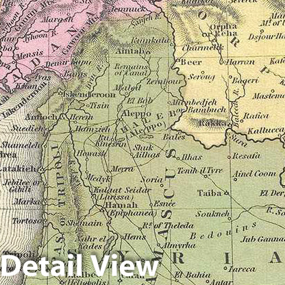
Historic Map : Mitchell Map of Turkey in Asia (Palestine, Syria, Iraq, Turkey), 1849, Vintage Wall Art
Historic Map : Mitchell Map of Turkey in Asia (Palestine, Syria, Iraq, Turkey), 1849, Vintage Wall Art
Note: Sold out or unavailable
Couldn't load pickup availability
S. A. Mitchell's 1849 map of Turkey in Asia. Centered on the Holy Land, this map covers the Asian territories claimed by the Turkish Ottoman Empire. These include the modern day countries of Turkey, Cyprus, Syria, Jordan, Lebanon, and Iraq. An inset in the lower left quadrant details the environs of Constantinople and the Bosporus Straits. The important caravan route from to Rosrah, on the Persian Gulf, is noted. Political and topographical features are noted and color coded with elevation rendered by hachure.
The whole is engraved and colored in Mitchell's distinctive style with green border work and vivid pastels. Mitchell published this chart in his atlas from 1846 to the late 1850s before discontinuing the series and selling his map plates to DeSilver. This map was issued in the 1849 edition of the New Universal Atlas. It was the last edition of that atlas to be published by Mitchell prior to selling the plates and rights to the atlas to Thomas Cowperthwait in 1850.
- MUSEUM QUALITY INKS AND PAPER: Printed on thick 192gsm heavyweight matte paper with archival giclee inks, this historic fine art will decorate your wall for years to come.
- VINTAGE MAP REPRODUCTION: Add style to any room's decor with this beautiful print. Whether your interior design is modern or classic, a map is never out of fashion.
- ATTENTION TO DETAIL: We edit every antique map for image quality, color and vibrance, so it can look its best while retaining historical character. Makes a great gift!
- FRAME READY: Your unframed poster will arrive crease-free, rolled in a sturdy mailing tube. Many maps fit easy-to-find standard size frames 16x20, 16x24, 18x24, 24x30, 24x36, saving on custom framing.
- Watermarks will not appear in the printed picture. Some blemishes, tears, or stamps may be removed from the final print.
Why choose Historic Pictoric
Every artwork we offer is carefully edited by our small but dedicated team of image professionals, ensuring each detail is perfect. We print every order to demand right here in the USA, treating every piece with the same care and attention we would give our own work. From editing to printing to packaging, we take pride in delivering artwork that meets our high standards—and we love knowing it’s heading to a home where it will be appreciated.