-
-


-
Wall Color
in
Uncheck to hide the white line Check to show the white line -
-
.


Frame
Room
Gallery
Historic Map : Paraguay, Paraguay River Composite: Carte de la Partie Meridionale de la Republique du Paraguay 1861 , Vintage Wall Art
Historic Map : Paraguay, Paraguay River Composite: Carte de la Partie Meridionale de la Republique du Paraguay 1861 , Vintage Wall Art
Note: Sold out or unavailable
Couldn't load pickup availability
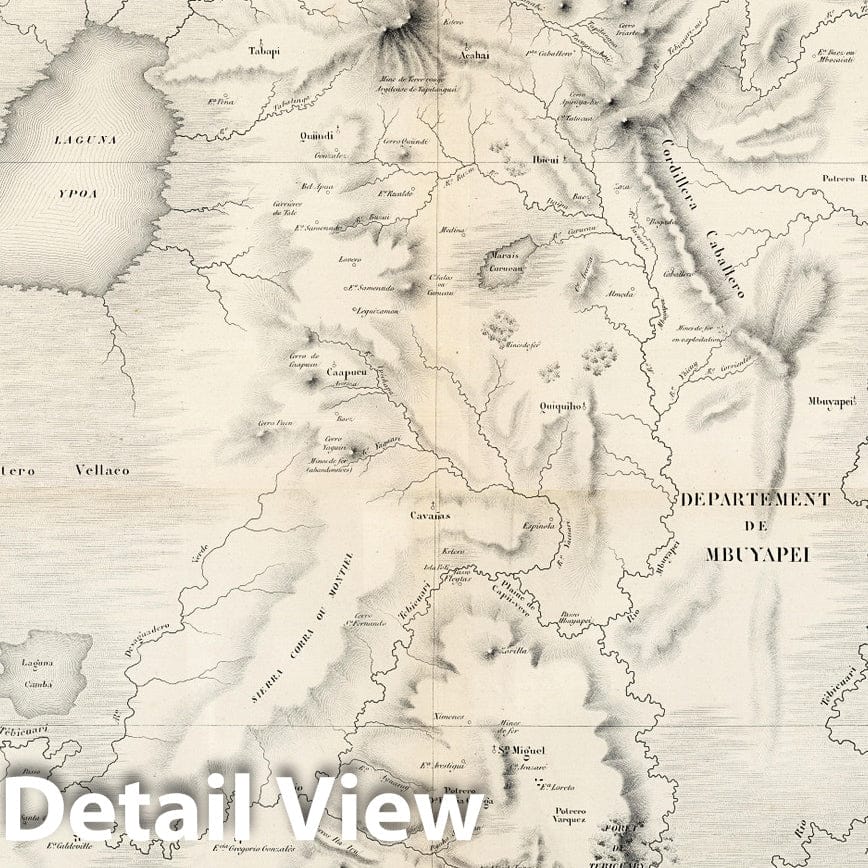
Carte de la Partie Meridionale de la Republique du Paraguay. Dressee par E. Mouchez Lieutt. de Vau. commt. l'Aviso à vapeur le Bisson a l'aide des observations faites et des documents recueillis sur les lieux pendant les trois voyages du Bisson en 1857-58-59. Depot des cartes et plans de la marine. 1861. Paris : Imp. Aug. Bry, R. du Bac 114. PRIX. Grave chez Delamare. Deux France. | Carte de la Partie Meridionale de la Republique du Paraguay. Dressee par E. Mouchez Lieutt. de Vau. commt. l'Aviso à vapeur le Bisson a l'aide des observations faites et des documents recueillis sur les lieux pendant les trois voyages du Bisson en 1857-58-59. Depot des cartes et plans de la marine. 1861. Paris : Imp. Aug. Bry, R. du Bac 114. PRIX. Grave chez Delamare. Deux France. | Uncolored map of Paraguay on 2 sheets, 57x77.5 and 56x77.5, prepared by Ernest Amedee Barthelemy Mouchez, a French naval officer who became director of the Paris Observatory and launched the ill-fated Carte du Ciel project in 1887. According to the title the information was gathered during his voyages in 1857 - 1859 on the steamship "Bisson" and published by the French "Depot des cartes et plans de la Marine". The map contains the results of Mouchez's expeditions up the Parana and Paraguay River, making observations from 1857 to 1860. Mouchez improved the practice of surveying at sea, adapting terrestrial instruments for naval use, and was especially concerned with the problems of determining longitude. He developed the use of the theodolite and meridian telescope. Title on upper sheet. "No. 1933. No. 1934" on upper and lower right margin of map. Shows political boundaries, major cities, rivers, military posts, etc. Relief shown by hachures. Prime meridian is Paris.
We print high quality reproductions of historical maps, photographs and prints. Some of these images may show signs of wear and tear - we believe that in many cases this contributes to the aesthetics of the item.
- MUSEUM QUALITY INKS AND PAPER: Printed on thick 192gsm heavyweight matte paper with archival giclee inks, this historic fine art will decorate your wall for years to come.
- VINTAGE MAP REPRODUCTION: Add style to any room's decor with this beautiful print. Whether your interior design is modern or classic, a map is never out of fashion.
- ATTENTION TO DETAIL: We edit every antique map for image quality, color and vibrance, so it can look its best while retaining historical character. Makes a great gift!
- FRAME READY: Your unframed poster will arrive crease-free, rolled in a sturdy mailing tube. Many maps fit easy-to-find standard size frames 16x20, 16x24, 18x24, 24x30, 24x36, saving on custom framing.
- Watermarks will not appear in the printed picture. Some blemishes, tears, or stamps may be removed from the final print.
Why choose Historic Pictoric
Every artwork we offer is carefully edited by our small but dedicated team of image professionals, ensuring each detail is perfect. We print every order to demand right here in the USA, treating every piece with the same care and attention we would give our own work. From editing to printing to packaging, we take pride in delivering artwork that meets our high standards—and we love knowing it’s heading to a home where it will be appreciated.