-
-


-
Wall Color
in
Uncheck to hide the white line Check to show the white line -
-
.


Frame
Room
Gallery
Historic Map : Peru , Ilo (Peru), Chart Map, Mollendo, Ilo. 1824 , Vintage Wall Art
Historic Map : Peru , Ilo (Peru), Chart Map, Mollendo, Ilo. 1824 , Vintage Wall Art
Note: Sold out or unavailable
Couldn't load pickup availability
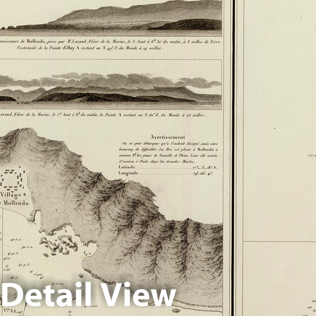
Plan de Mollendo, sur la cote du Perou. Leve en 1823 a bord de la Fregate la Clorinde, commandee par Mr. le Baron Mackau, Capitaine de Vaisseau, Gentilhomme de la Chambre du Roi. Par MM. Lartigue et Flury, Enseignes de Vaisseau. Publiee par ordre du Roi. Sous le Ministere de Son Exc. M. le Marquis de Clermont-Tonnerre, Pair de France, Secretaire d'Etat au Departement de la Marine et des Colonies. Au Depot-general de la Marine en 1824. Plan d'Ilo, sur la cote du Perou. Leve en 1823 par MM. Lartigue et Flury. Grave par Caplin. Ecrit par Besancon. | Neptune des cotes occidentales d'Amerique sur le Grand Ocean. | This volume 7 of Neptune Francois forms an extensive atlas of charts of the western coasts of North and South America, with most charts dated or updated to the 1820's. 25 charts are listed in the index, yet 36 charts are present here. This copy is from the library of the Duc d'Orleans. This issue must be later than the NMM 256, since it has 10 extra charts dated from 1823 to 1828; the latest date in NMM256 is 1822. The eight Vancouver charts appear to be original issues or restrikes from the original plates; the La Perouse charts are absolutely restrikes on newer paper, with the Mappe Monde updated in Australia to show the coastal discoveries in the south. The progression of engraving style from the La Perouse to the 1828 charts is most interesting. The charts of Mexico and South America are largely copies of the Spanish Marine charts issued in the early 1800s showing the Malaspina Expedition tracks (see W. Heckrotte's copy of the Spanish charts). Bound in full red leather covers with decorative gold border and the same titles as above stamped on the spine.
We print high quality reproductions of historical maps, photographs and prints. Some of these images may show signs of wear and tear - we believe that in many cases this contributes to the aesthetics of the item.
- MUSEUM QUALITY INKS AND PAPER: Printed on thick 192gsm heavyweight matte paper with archival giclee inks, this historic fine art will decorate your wall for years to come.
- VINTAGE MAP REPRODUCTION: Add style to any room's decor with this beautiful print. Whether your interior design is modern or classic, a map is never out of fashion.
- ATTENTION TO DETAIL: We edit every antique map for image quality, color and vibrance, so it can look its best while retaining historical character. Makes a great gift!
- FRAME READY: Your unframed poster will arrive crease-free, rolled in a sturdy mailing tube. Many maps fit easy-to-find standard size frames 16x20, 16x24, 18x24, 24x30, 24x36, saving on custom framing.
- Watermarks will not appear in the printed picture. Some blemishes, tears, or stamps may be removed from the final print.
Why choose Historic Pictoric
Every artwork we offer is carefully edited by our small but dedicated team of image professionals, ensuring each detail is perfect. We print every order to demand right here in the USA, treating every piece with the same care and attention we would give our own work. From editing to printing to packaging, we take pride in delivering artwork that meets our high standards—and we love knowing it’s heading to a home where it will be appreciated.