-
-


-
Wall Color
in
Uncheck to hide the white line Check to show the white line -
-
.


Frame
Room
Gallery
Historic Map : Pictorial Pocket Map or Plan of The City of Venice, Italy, 1940, Vintage Wall Art
Historic Map : Pictorial Pocket Map or Plan of The City of Venice, Italy, 1940, Vintage Wall Art
Note: Sold out or unavailable
Couldn't load pickup availability
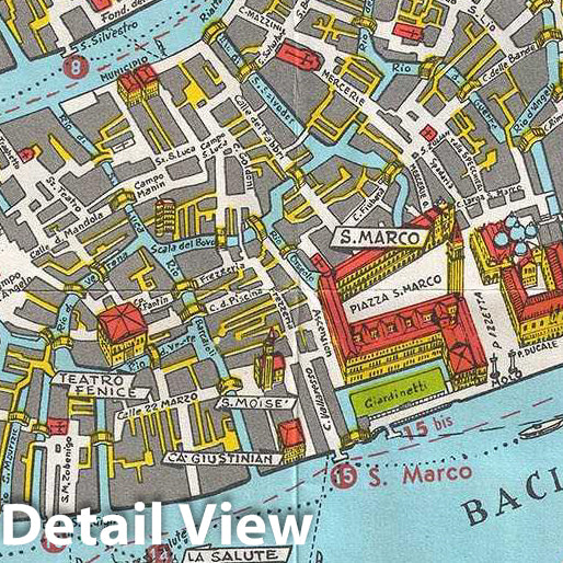
This is a beautiful c. 1940 map or city plan of Venice, Italy issued by the Unione Italiana Lotta alla Distrofia Muscolare. It covers Venice from the Pointe della Liberta Isola di S. Elena and from Giudecca north to San Michele. The map details streets, canals, parks, islands, transportation lines and a host of other topographical features. Important buildings are shown in profile. A large inset in the top right features the region surrounding Venice. Another inset in the bottom right depicts Lido. A key included near the bottom border notes the 20 landmarks numbered on the map. Verso of the map features a map of Canal Grande and notes the various buildings along the banks. A key to the buildings is also provided. Verso also features text and other information useful to the tourist. This map was issued by the Unione Italiana Lotta alla Distrofia Muscolare or U. I. L. D. M.
- MUSEUM QUALITY INKS AND PAPER: Printed on thick 192gsm heavyweight matte paper with archival giclee inks, this historic fine art will decorate your wall for years to come.
- VINTAGE MAP REPRODUCTION: Add style to any room's decor with this beautiful print. Whether your interior design is modern or classic, a map is never out of fashion.
- ATTENTION TO DETAIL: We edit every antique map for image quality, color and vibrance, so it can look its best while retaining historical character. Makes a great gift!
- FRAME READY: Your unframed poster will arrive crease-free, rolled in a sturdy mailing tube. Many maps fit easy-to-find standard size frames 16x20, 16x24, 18x24, 24x30, 24x36, saving on custom framing.
- Watermarks will not appear in the printed picture. Some blemishes, tears, or stamps may be removed from the final print.
Why choose Historic Pictoric
Every artwork we offer is carefully edited by our small but dedicated team of image professionals, ensuring each detail is perfect. We print every order to demand right here in the USA, treating every piece with the same care and attention we would give our own work. From editing to printing to packaging, we take pride in delivering artwork that meets our high standards—and we love knowing it’s heading to a home where it will be appreciated.