-
-


-
Wall Color
in
Uncheck to hide the white line Check to show the white line -
-
.


Frame
Room
Gallery
Historic Map : Rand McNally map of Eastern Asia and Western Pacific Ocean, 1945 - Vintage Wall Art
Historic Map : Rand McNally map of Eastern Asia and Western Pacific Ocean, 1945 - Vintage Wall Art
Note: Sold out or unavailable
Couldn't load pickup availability
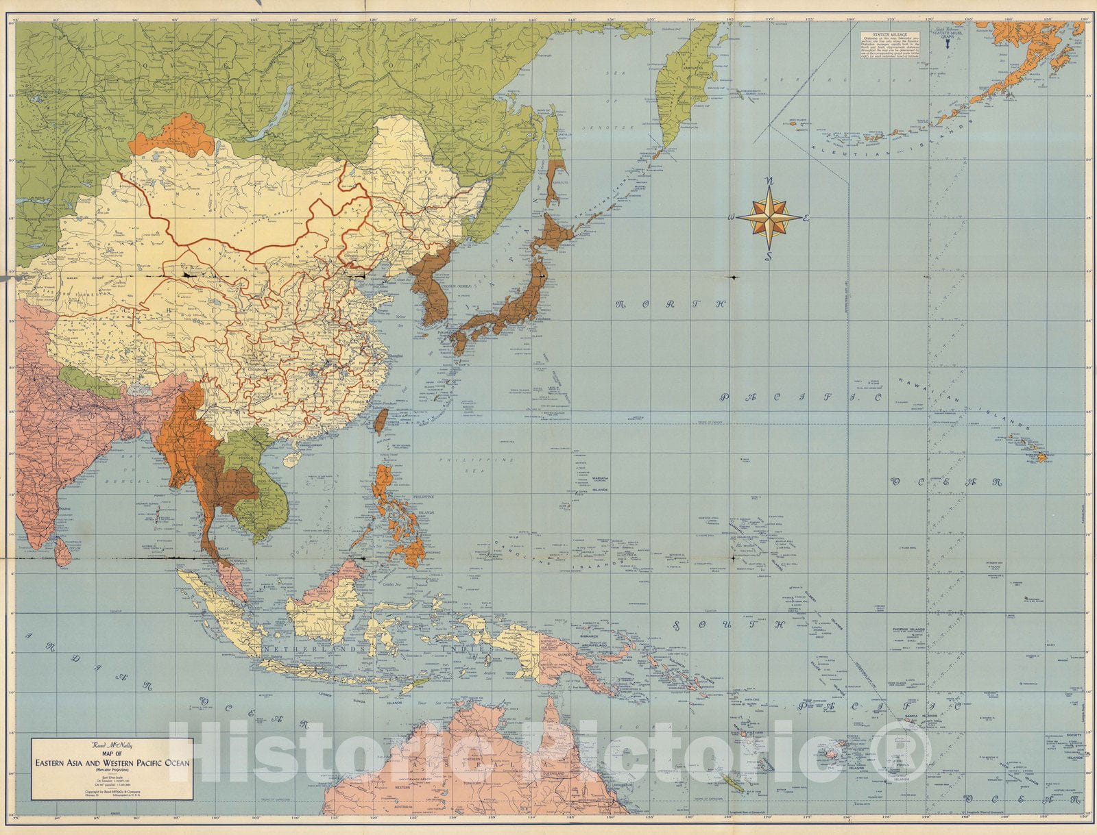
Rand McNally map of Eastern Asia and Western Pacific Ocean. (Mercator projection). Copyright by Rand McNally & Company; Chicago, Ill. Lithographed in U.S.A. (Cover title) Rand McNally War Map of the Pacific War area. Prepared exclusively for St. Paul Fire and Marine Insurance Company, Mercury Insurance Company, Saint Paul- Mercury Indemnity Company. Home Office, St. Paul, Minnesota. Complements of Carl Gallaway - Insurance - Eureka, Utah. (on verso) Rand McNally Stratoview map of Eastern Asia. (with) Rand McNally; Populated map of Japan. (with) Populated map of Philippine Islands. | Rand McNally map of Eastern Asia and Western Pacific Ocean. Mercator projection. Copyright by Rand McNally & Company; Chicago, Ill. Lithographed in U.S.A. (Cover title) Rand McNally War Map of the Pacific War area. Prepared exclusively for St. Paul Fire and Marine Insurance Company, Mercury Insurance Company, Saint Paul- Mercury Indemnity Company. Home Office, St. Paul, Minnesota. Complements of Carl Gallaway - Insurance - Eureka, Utah. (on verso) Rand McNally Stratoview map of Eastern Asia. (with) Rand McNally; Populated map of Japan. (with) Populated map of Philippine Islands. | Full color tour map of the Pacific Theater of World War II, on sheet 105x78, folded into self wrapped cover 35x27. Date estimated. Showing airline distances, islands. ports and other strategic points. Map of Eastern Asia on cover. On verso: there are three maps with insets and a text: "The Eastern Asia Threatre of Japanese Defeat," is the best way to date this map as having been made during World War II. The Russian did not begin their offensive against the Japanese until August 1945, and by the following this clearly had not happened.
We print high quality reproductions of historical maps, photographs and prints. Some of these images may show signs of wear and tear - we believe that in many cases this contributes to the aesthetics of the item.
- MUSEUM QUALITY INKS AND PAPER: Printed on thick 192gsm heavyweight matte paper with archival giclee inks, this historic fine art will decorate your wall for years to come.
- VINTAGE MAP REPRODUCTION: Add style to any room's decor with this beautiful print. Whether your interior design is modern or classic, a map is never out of fashion.
- ATTENTION TO DETAIL: We edit every antique map for image quality, color and vibrance, so it can look its best while retaining historical character. Makes a great gift!
- FRAME READY: Your unframed poster will arrive crease-free, rolled in a sturdy mailing tube. Many maps fit easy-to-find standard size frames 16x20, 16x24, 18x24, 24x30, 24x36, saving on custom framing.
- Watermarks will not appear in the printed picture. Some blemishes, tears, or stamps may be removed from the final print.
What our customers are saying
★★★★★I purchased an historic map, 16x24 inch. It is beautifully printed on heavy stock. The lettering, colors, and details of the map are crisp and easy to read. I am highly satisfied and would certainly purchase from Historic Pictoric again!
Kent A.
★★★★★Ordered the Pan American Midway print to fit a lovely thrift-store gilded frame. I love showing off Buffalo's rich history and this is a pretty entertaining photo from 1901. Prompt shipping. Sturdy packaging.
Cindy O.
★★★★★I received my print within days of ordering, and it arrived well packed in a mailing tube. The print is high quality and exactly as advertised. I will use Historic Pictoric again in the future!
Cheryl H.
★★★★★Excellent product. Great fidelity in reproduction of the original. Fine/minute details were sharp, colors were vibrant, and thickness, texture and overall feel and quality of the paper were excellent. Very satisfied with my purchase.
Konrad B.
★★★★★I have purchased six maps from Historic Pictoric. I find the quality to be excellent. Their customers service is also excellent. Outstanding! I called to exchange a few for different sizes and I could not have asked for a better experience.
Aaron C.
★★★★★The original map I ordered lacked some of the detail that I had hoped for, but they responded with several more map possibilities to choose from. Excellent service- a far step beyond what anyone expects from online purchases.
Dan M.
★★★★★I am a owner of 5 maps from Historic Pictoric. From Okinawa, 1945, Europe 1940-1945 battle maps. Now they’re helping me with the battle of Gettysburg. These maps are so much superior to the map on a page in a book. I have framed two of them.
Steven Ko
★★★★★Great heavy paper quality and clarity of my nautical map. Will be a great addition to our home close to the beach!
Jennifer A