-
-


-
Wall Color
in
Uncheck to hide the white line Check to show the white line -
-
.


Frame
Room
Gallery
Historic Map : Sanson and Mariette Map of The British Isles, 1650, Vintage Wall Art
Historic Map : Sanson and Mariette Map of The British Isles, 1650, Vintage Wall Art
Note: Sold out or unavailable
Couldn't load pickup availability
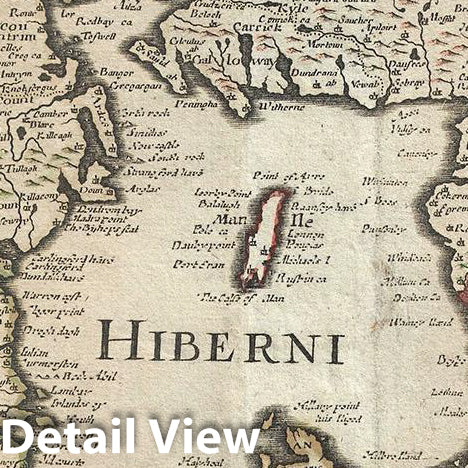
This is a beautiful c. 1650 map of the British Isles by Pierre Mariette and Nicolas Sanson. Covers all of England, Scotland, Wales and Ireland. Includes a small inset of the Orkney Islands in the top right quadrant. Beautifully detailed, it notes important cities, villages, lakes, rivers, islands and other topographic features with mountains and forests rendered in profile. The Wall of Hadrian, fortifications built by the Roman Empire to defend against the unruly tribes of the north, is noted.
In the surrounding waters, ships, galleons and a sea monster are illustrated. A decorative title cartouche adorns the top left quadrant. This map was issued by Pierre Mariette and Nicolas Sanson c. 1650.
- MUSEUM QUALITY INKS AND PAPER: Printed on thick 192gsm heavyweight matte paper with archival giclee inks, this historic fine art will decorate your wall for years to come.
- VINTAGE MAP REPRODUCTION: Add style to any room's decor with this beautiful print. Whether your interior design is modern or classic, a map is never out of fashion.
- ATTENTION TO DETAIL: We edit every antique map for image quality, color and vibrance, so it can look its best while retaining historical character. Makes a great gift!
- FRAME READY: Your unframed poster will arrive crease-free, rolled in a sturdy mailing tube. Many maps fit easy-to-find standard size frames 16x20, 16x24, 18x24, 24x30, 24x36, saving on custom framing.
- Watermarks will not appear in the printed picture. Some blemishes, tears, or stamps may be removed from the final print.
Why choose Historic Pictoric
Every artwork we offer is carefully edited by our small but dedicated team of image professionals, ensuring each detail is perfect. We print every order to demand right here in the USA, treating every piece with the same care and attention we would give our own work. From editing to printing to packaging, we take pride in delivering artwork that meets our high standards—and we love knowing it’s heading to a home where it will be appreciated.
- Choosing a selection results in a full page refresh.
- Opens in a new window.