-
-


-
Wall Color
in
Uncheck to hide the white line Check to show the white line -
-
.


Frame
Room
Gallery
Historic Map : S.D.U.K. Map of Ancient Libya, Barbary Coast, Northern Africa, 1840, Vintage Wall Art
Historic Map : S.D.U.K. Map of Ancient Libya, Barbary Coast, Northern Africa, 1840, Vintage Wall Art
Note: Sold out or unavailable
Couldn't load pickup availability
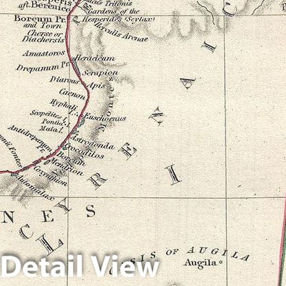
This is a fine example of the 1840 Society for the Diffusion of Useful Knowledge or S.D.U.K. map of northern Africa in ancient times. It depicts the various ancient kingdoms and offers a good detail in the deserts - some of which is entirely speculative. Depicts the ancient regions of Tripolitania, Cyrenaica, Marmarica, Phazania and Aegyptus. Various ancient cities along the coast, rivers, mountains and other topographical details are noted, with relief shown by hachure. A note in the bottom right quadrant remarks, 'In this map several names of places and tribes have been omitted on the count of the impossibility of assigning their true positions. Some of the names which are inserted are very uncertain.' The Garamantes, the earliest known name of a tribe that was the ancestor of the Berber people, is noted.
The Carthaginian Empire was formed after Carthage gained independence from the Phoenician colonies in 650 BC. Carthage became the center for trade and the Carthaginian Empire dominated much of the region, until Numidia, the Kingdom to the west of Carthage, allied itself with Rome in 206 BC leading the Roman conquest of the region in 201 BC. By the end of the third Punic war, the city of Carthage was leveled by Rome, thus ending its independent existence. Carthage's great general Hannibal, nearly conquered Rome with his highly trained war elephants, before being turned back at the very brink of victory.
This map was originally copyrighted in 1840, but was issued in Volume two of Chapman and Hall's 1844 edition of Maps of the Society for the Diffusion of Useful Knowledge. It was engraved by John Walker of J. and C. Walker.
- MUSEUM QUALITY INKS AND PAPER: Printed on thick 192gsm heavyweight matte paper with archival giclee inks, this historic fine art will decorate your wall for years to come.
- VINTAGE MAP REPRODUCTION: Add style to any room's decor with this beautiful print. Whether your interior design is modern or classic, a map is never out of fashion.
- ATTENTION TO DETAIL: We edit every antique map for image quality, color and vibrance, so it can look its best while retaining historical character. Makes a great gift!
- FRAME READY: Your unframed poster will arrive crease-free, rolled in a sturdy mailing tube. Many maps fit easy-to-find standard size frames 16x20, 16x24, 18x24, 24x30, 24x36, saving on custom framing.
- Watermarks will not appear in the printed picture. Some blemishes, tears, or stamps may be removed from the final print.
Why choose Historic Pictoric
Every artwork we offer is carefully edited by our small but dedicated team of image professionals, ensuring each detail is perfect. We print every order to demand right here in the USA, treating every piece with the same care and attention we would give our own work. From editing to printing to packaging, we take pride in delivering artwork that meets our high standards—and we love knowing it’s heading to a home where it will be appreciated.
- Choosing a selection results in a full page refresh.
- Opens in a new window.