-
-


-
Wall Color
in
Uncheck to hide the white line Check to show the white line -
-

-


 Frame
Frame Room
Room Gallery
Historic Map : S.D.U.K. Map of Egypt, 1831, Vintage Wall Art
Historic Map : S.D.U.K. Map of Egypt, 1831, Vintage Wall Art
Note: Sold out or unavailable
Couldn't load pickup availability
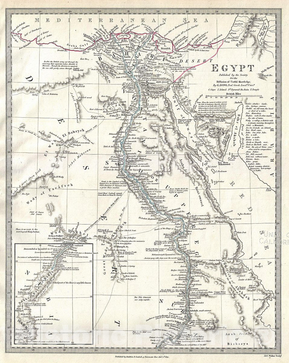
This is a beautiful example of an 1831 Society for the Diffusion of Useful Knowledge or S.D.U.K. map of Egypt. It depicts Egypt, centered on the Nile River from its delta on the Mediterranean south as far as Nubia and from the Gulf of Buschaifa east as far as the Dead Sea. The map names numerous tribes throughout, and offers other interesting cartographic annotations, such as 'In 1801 the British army cut through the causeway that separates Lakes Aboukir and Mareotis. Though the division in repaired, the sea still partly comes through.' The map also notes numerous cities and villages along the river as well as various ancient Egyptian ruins including the Pyramids of Giza. Near Suez, the map identifies the Ancient Canal which would soon give way to a more modern variant. Numerous caravan routes are mapped throughout. An inset in the lower left quadrant features part of Sudan.
This map was prepared in the declining days of the Ottoman Empire. After the conquest of Palestine by Muhammad Ali's Egypt in 1832, British intervention returned control of Palestine to the Ottoman rulers in 1840. In Egypt, following the expulsion of the Napoleonic forces by the Ottoman Mamluk Turks, Muhammad Ali, the Ottoman viceroy of Egypt, established the Mamluk dynasty that would rule Egypt until the Egyptian Revolution of 1952. Between 1820 and 1833, Ali annexed northern Sudan, Syria and parts of Arabia into the Mamluk Empire.
This map was originally published by Baldwin and Cradock and copyrighted in 1831, but was issued in Volume two of Chapman and Hall's 1844 edition of Maps of the Society for the Diffusion of Useful Knowledge. It was engraved by John Walker of J. and C. Walker.
- VINTAGE MAP REPRODUCTION: Add style to any room's decor with this beautiful decorative print. Whether your interior design is modern, rustic or classic, a map is never out of fashion
- MUSEUM QUALITY INKS AND PAPER: Printed on thick 192gsm heavyweight matte paper with archival giclee inks, this historic fine art will decorate your wall for years to come
- ARTWORK MADE TO ORDER IN THE USA: We make each reprint only when you order it. Every antique map is edited for image quality, color and vibrance, so it can look its best while retaining historical character. Makes a great gift!
- FRAME READY: Your unframed poster ships crease-free, rolled in a sturdy mailing tube. Many maps fit easy-to-find standard size frames 16x20, 16x24, 18x24, 24x30, 24x36, saving on custom framing
- Watermarks will not appear in the printed picture. Old maps sometimes have blemishes, tears, or stamps that may be removed from the final print
Why choose Historic Pictoric
Every artwork we offer is carefully edited by our small but dedicated team of image professionals, ensuring each detail is perfect. We print every order to demand right here in the USA, treating every piece with the same care and attention we would give our own work. From editing to printing to packaging, we take pride in delivering artwork that meets our high standards—and we love knowing it’s heading to a home where it will be appreciated. What our customers say.