-
-


-
Wall Color
in
Uncheck to hide the white line Check to show the white line -
-
.


Frame
Room
Gallery
Historic Map : Vaugondy, Diderot Map of Asia, Alaska, and The Northeast Passage , 1772, Vintage Wall Art
Historic Map : Vaugondy, Diderot Map of Asia, Alaska, and The Northeast Passage , 1772, Vintage Wall Art
Note: Sold out or unavailable
Couldn't load pickup availability
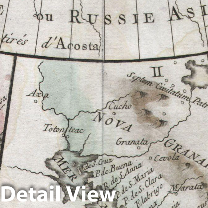
A map of the Northeast Passage, the northeast coasts of Asia, and the American Northwest. The Northeast Passage, much like American's Northwest Passage, was a long sought after sea route through the Arctic that would save European merchantman the expense of rounding Africa in order to access the trade riches of East Asia. This map deals primarily with Asiatic Russia, detailing the Northeast Passage from Norway and Iceland westward as far as Alaska (Anian), Kamschatka, Yesso, and Japan. Knowledge of this area was, at the time, speculative at best and this is reflected in the map. Shows many unknown islands, misshapen representations of Kamtschaka, Japan, Hokkaido (Yesso), and Alaska. Notes Peking (Beijing), Nanking (Nanjing), Corea (Korea), Jedo (Tokyo)and Nangasaki (Nagasaki). All four loosely reference Wytfliet's seminal 1597 American Atlas . The upper left inset (I), depicts the northwest coast of America from the Bay of California to a conjectural Alaska, a misshapen Japan and a mysterious I. de Plata. Depicts the mythical city of Quivira on the Alaskan coast. This map was based upon the California sheet of Wytfliet's Atlas. Inset (II), also drawn from the Wytfliet California, shows the Bay of California and Nova Granada. Plate (III) depicts the Conibas-Zubgara region. This region, which appeared first in Mercator's 1569 atlas has been loosely interoperated, depending upon the source, as the Northwest Passage, the Hudson Bay, or the first map of the Great Lakes. Plate IV shows what is almost certainly Alaska, labeled Anian Regnum . Here is a real cartographic curiosity, where myth become fact, which again becomes myth. This map is part of the 10 map series prepared by Vaugondy for the Supplement to Diderot's Encyclopédie , of which this is plate 2. This seminal map series, exploring the mapping of North American and specifically the Northwest Passage was one of the first studies in comparative cartography.
- MUSEUM QUALITY INKS AND PAPER: Printed on thick 192gsm heavyweight matte paper with archival giclee inks, this historic fine art will decorate your wall for years to come.
- VINTAGE MAP REPRODUCTION: Add style to any room's decor with this beautiful print. Whether your interior design is modern or classic, a map is never out of fashion.
- ATTENTION TO DETAIL: We edit every antique map for image quality, color and vibrance, so it can look its best while retaining historical character. Makes a great gift!
- FRAME READY: Your unframed poster will arrive crease-free, rolled in a sturdy mailing tube. Many maps fit easy-to-find standard size frames 16x20, 16x24, 18x24, 24x30, 24x36, saving on custom framing.
- Watermarks will not appear in the printed picture. Some blemishes, tears, or stamps may be removed from the final print.
Why choose Historic Pictoric
Every artwork we offer is carefully edited by our small but dedicated team of image professionals, ensuring each detail is perfect. We print every order to demand right here in the USA, treating every piece with the same care and attention we would give our own work. From editing to printing to packaging, we take pride in delivering artwork that meets our high standards—and we love knowing it’s heading to a home where it will be appreciated.