-
-


-
Wall Color
in
Uncheck to hide the white line Check to show the white line -
-
.


Frame
Room
Gallery
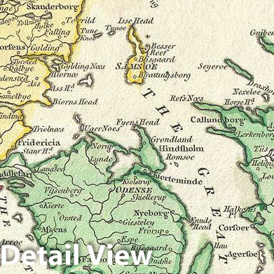
Historic Map : Wilkinson Map of Denmark and Holstein, 1793, Vintage Wall Art
Historic Map : Wilkinson Map of Denmark and Holstein, 1793, Vintage Wall Art
Note: Sold out or unavailable
Couldn't load pickup availability
This is a finely detailed 1793 map of Denmark and Holstein, by Robert Wilkinson. It covers all of Denmark including the Duchy of Holstein.
Denmark prospered greatly in the last decades of the 18th century because its neutral status allowed it to trade with both sides in the many contemporary wars. In the Napoleonic Wars, Denmark originally tried to pursue a policy of neutrality to continue the lucrative trade with both France and Great Britain and joined the League of Armed Neutrality with Russia, Sweden and Prussia.
This map was engraved by Thomas Conder and issued as plate no. 5 in the 1792 edition of Robert Wilkinson's General Atlas.
- MUSEUM QUALITY INKS AND PAPER: Printed on thick 192gsm heavyweight matte paper with archival giclee inks, this historic fine art will decorate your wall for years to come.
- VINTAGE MAP REPRODUCTION: Add style to any room's decor with this beautiful print. Whether your interior design is modern or classic, a map is never out of fashion.
- ATTENTION TO DETAIL: We edit every antique map for image quality, color and vibrance, so it can look its best while retaining historical character. Makes a great gift!
- FRAME READY: Your unframed poster will arrive crease-free, rolled in a sturdy mailing tube. Many maps fit easy-to-find standard size frames 16x20, 16x24, 18x24, 24x30, 24x36, saving on custom framing.
- Watermarks will not appear in the printed picture. Some blemishes, tears, or stamps may be removed from the final print.
Why choose Historic Pictoric
Every artwork we offer is carefully edited by our small but dedicated team of image professionals, ensuring each detail is perfect. We print every order to demand right here in the USA, treating every piece with the same care and attention we would give our own work. From editing to printing to packaging, we take pride in delivering artwork that meets our high standards—and we love knowing it’s heading to a home where it will be appreciated.