-
-


-
Wall Color
in
Uncheck to hide the white line Check to show the white line -
-
.


Frame
Room
Gallery
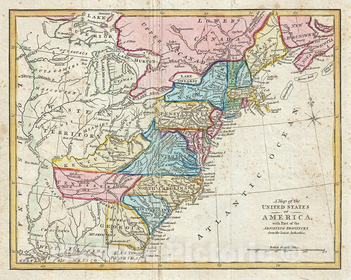
Historic Map : Wilkinson Map of The United States, 1794, Vintage Wall Art
Historic Map : Wilkinson Map of The United States, 1794, Vintage Wall Art
Note: Sold out or unavailable
Couldn't load pickup availability
This is an unusual and ephemeral 1794 first edition map of the United States by Robert Wilkinson. Wilkinson's map covers the United States from the Mississippi River to the Atlantic seaboard and from the Great Lakes and Canada to Florida, which at the time was a Spanish possession. Beautiful original color work defines political regions.
Of particular interest is Wilkinson's treatment of the western parts of the United States, including a vast Western Territory extending from western Georgia, around Tennessee, northwards as far as the Great Lakes, and eastward as far as Pennsylvania and Virginia. At the time this only tentatively explored region was dominated by various powerful and populous American Indian nations including the Choctaws, Muskogee, Chickasaw, Illinois, Miami, Cherokee, and others. Soon these lands would be organized by the Federal government into territories and eventually new states, a process which would eventually lead to the early 19th century displacement of the various indigenous peoples known as the Trail of Tears.
Maine, far to the north, is identified as 'Belonging to the Massachusetts Bay.' Following the Revolutionary War Maine was treated as an enclave of Massachusetts. During the War of 1812 Massachusetts failed to protect Maine from British attempts to establish a colony there called New Ireland. Though the British were ultimately driven out, the failure of the Massachusetts militia led to general bitterness towards Massachusetts and calls for Maine's statehood – which were answered in 1820.
This colorful map was published in 1794 by R. Wilkinson of no. 58 Cornhill, London for issued in the first edition of Wilkinson's General Atlas.
- MUSEUM QUALITY INKS AND PAPER: Printed on thick 192gsm heavyweight matte paper with archival giclee inks, this historic fine art will decorate your wall for years to come.
- VINTAGE MAP REPRODUCTION: Add style to any room's decor with this beautiful print. Whether your interior design is modern or classic, a map is never out of fashion.
- ATTENTION TO DETAIL: We edit every antique map for image quality, color and vibrance, so it can look its best while retaining historical character. Makes a great gift!
- FRAME READY: Your unframed poster will arrive crease-free, rolled in a sturdy mailing tube. Many maps fit easy-to-find standard size frames 16x20, 16x24, 18x24, 24x30, 24x36, saving on custom framing.
- Watermarks will not appear in the printed picture. Some blemishes, tears, or stamps may be removed from the final print.
What our customers are saying
★★★★★I purchased an historic map, 16x24 inch. It is beautifully printed on heavy stock. The lettering, colors, and details of the map are crisp and easy to read. I am highly satisfied and would certainly purchase from Historic Pictoric again!
Kent A.
★★★★★Ordered the Pan American Midway print to fit a lovely thrift-store gilded frame. I love showing off Buffalo's rich history and this is a pretty entertaining photo from 1901. Prompt shipping. Sturdy packaging.
Cindy O.
★★★★★I received my print within days of ordering, and it arrived well packed in a mailing tube. The print is high quality and exactly as advertised. I will use Historic Pictoric again in the future!
Cheryl H.
★★★★★Excellent product. Great fidelity in reproduction of the original. Fine/minute details were sharp, colors were vibrant, and thickness, texture and overall feel and quality of the paper were excellent. Very satisfied with my purchase.
Konrad B.
★★★★★I have purchased six maps from Historic Pictoric. I find the quality to be excellent. Their customers service is also excellent. Outstanding! I called to exchange a few for different sizes and I could not have asked for a better experience.
Aaron C.
★★★★★The original map I ordered lacked some of the detail that I had hoped for, but they responded with several more map possibilities to choose from. Excellent service- a far step beyond what anyone expects from online purchases.
Dan M.
★★★★★I am a owner of 5 maps from Historic Pictoric. From Okinawa, 1945, Europe 1940-1945 battle maps. Now they’re helping me with the battle of Gettysburg. These maps are so much superior to the map on a page in a book. I have framed two of them.
Steven Ko
★★★★★Great heavy paper quality and clarity of my nautical map. Will be a great addition to our home close to the beach!
Jennifer A