-
-


-
Wall Color
in
Uncheck to hide the white line Check to show the white line -
-
.


Frame
Room
Gallery
Historic Map : Woodward Map of The Louisiana Purchase Exposition, St. Louis, Missouri, 1903, Vintage Wall Art
Historic Map : Woodward Map of The Louisiana Purchase Exposition, St. Louis, Missouri, 1903, Vintage Wall Art
Note: Sold out or unavailable
Couldn't load pickup availability
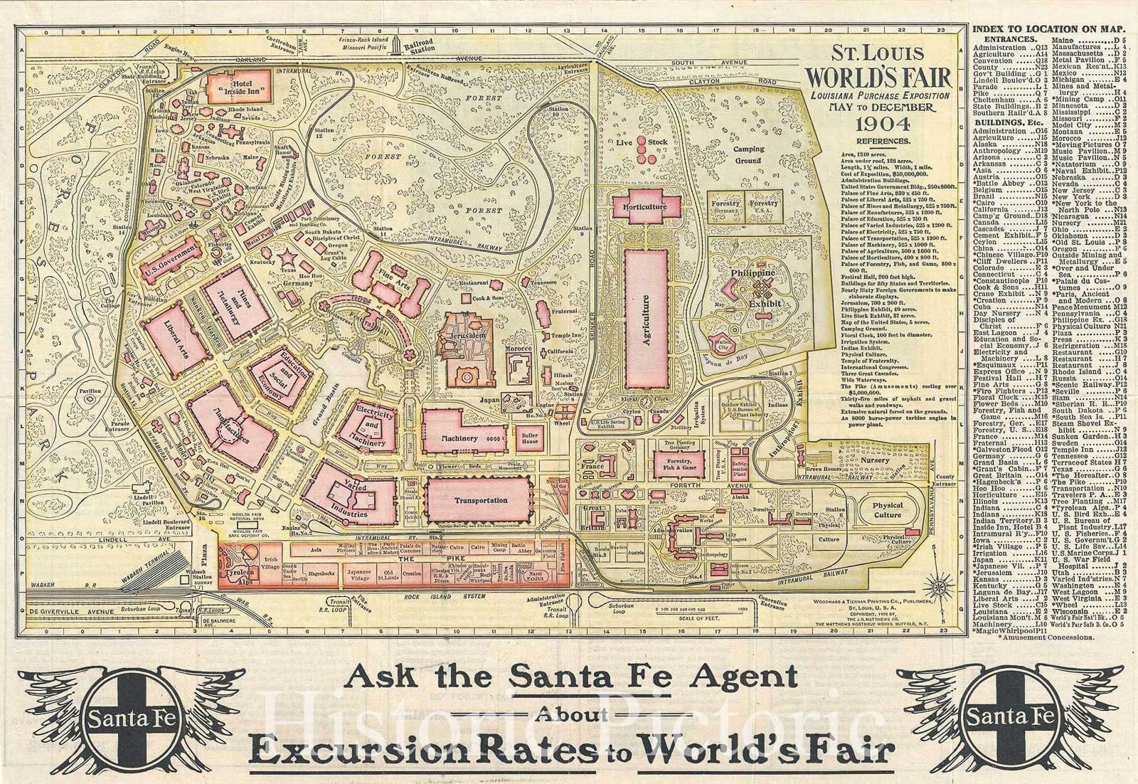
This is an appealing 1903 ground plan or map of the Louisiana Purchase exposition of the St. Louis World's Fair held in St. Louis, Missouri. The map, oriented with north at the bottom, covers the exposition grounds from Forest Park to Pennsylvania Avenue, naming all important buildings, walks, transportation lines, markets, landscape, and the various pavilions established for manufacturing, machinery, transportation, liberal arts, mines and metallurgy, fine arts, etc. A list below the title in the top right quadrant includes the dimensions of the various halls and buildings. An index of the locations on the map is also included along the right margin.
The Louisiana Purchase exposition, spanning 1240 acres and containing over 1500 buildings, was the largest World Fair to date. Over 50 countries and 44 U.S. States participated. The grounds, as shown here, were designed by George Kessler, one of the most influential architects and city planners of his time. The exhibits a human 'zoo' displaying indigenous peoples form newly acquired U.S. territories such as Guam, the Philippines, and Puerto Rico. It is also claimed that such American classics as the hamburger, the hot dog, the waffle style ice cream cone, and Dr. Pepper were first popularized here.
This map was copyrighted in 1903 by The J. N. Matthews Company., The Matthews Northrup Works, buffalo, NY. Published by Woodward and Tiernan Printed Company of St. Louis.
- MUSEUM QUALITY INKS AND PAPER: Printed on thick 192gsm heavyweight matte paper with archival giclee inks, this historic fine art will decorate your wall for years to come.
- VINTAGE MAP REPRODUCTION: Add style to any room's decor with this beautiful print. Whether your interior design is modern or classic, a map is never out of fashion.
- ATTENTION TO DETAIL: We edit every antique map for image quality, color and vibrance, so it can look its best while retaining historical character. Makes a great gift!
- FRAME READY: Your unframed poster will arrive crease-free, rolled in a sturdy mailing tube. Many maps fit easy-to-find standard size frames 16x20, 16x24, 18x24, 24x30, 24x36, saving on custom framing.
- Watermarks will not appear in the printed picture. Some blemishes, tears, or stamps may be removed from the final print.
What our customers are saying
★★★★★I purchased an historic map, 16x24 inch. It is beautifully printed on heavy stock. The lettering, colors, and details of the map are crisp and easy to read. I am highly satisfied and would certainly purchase from Historic Pictoric again!
Kent A.
★★★★★Ordered the Pan American Midway print to fit a lovely thrift-store gilded frame. I love showing off Buffalo's rich history and this is a pretty entertaining photo from 1901. Prompt shipping. Sturdy packaging.
Cindy O.
★★★★★I received my print within days of ordering, and it arrived well packed in a mailing tube. The print is high quality and exactly as advertised. I will use Historic Pictoric again in the future!
Cheryl H.
★★★★★Excellent product. Great fidelity in reproduction of the original. Fine/minute details were sharp, colors were vibrant, and thickness, texture and overall feel and quality of the paper were excellent. Very satisfied with my purchase.
Konrad B.
★★★★★I have purchased six maps from Historic Pictoric. I find the quality to be excellent. Their customers service is also excellent. Outstanding! I called to exchange a few for different sizes and I could not have asked for a better experience.
Aaron C.
★★★★★The original map I ordered lacked some of the detail that I had hoped for, but they responded with several more map possibilities to choose from. Excellent service- a far step beyond what anyone expects from online purchases.
Dan M.
★★★★★I am a owner of 5 maps from Historic Pictoric. From Okinawa, 1945, Europe 1940-1945 battle maps. Now they’re helping me with the battle of Gettysburg. These maps are so much superior to the map on a page in a book. I have framed two of them.
Steven Ko
★★★★★Great heavy paper quality and clarity of my nautical map. Will be a great addition to our home close to the beach!
Jennifer A