-
-


-
Wall Color
in
Uncheck to hide the white line Check to show the white line -
-
.


Frame
Room
Gallery
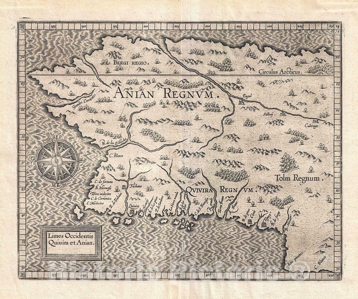
Historic Map : Wytfiet Map of Anian (Alaska, Pacific Northwest), 1607, Vintage Wall Art
Historic Map : Wytfiet Map of Anian (Alaska, Pacific Northwest), 1607, Vintage Wall Art
Note: Sold out or unavailable
Couldn't load pickup availability
A beautiful example of the 1607 edition of Cornelis avn Wytfliet's Anian Regnum. One of Wytfliet's more enigmatic productions, this map speculatively illustrates must of the west coast of the United States, Canada, and Alaska. Although significantly larger latitudinally, the westward reaching bulge bears a striking and purely coincidental resemblance to modern day Alaska. The basic cartography employed here by Wytfliet was derived from the 1569 world map of Gerard Mercator. Wytfliet identifies several cities and kingdoms, most of which are mythical. These include Anian, Quivira, and Tolm. He further identifies the cities of Tuchano, Quivira, Cicuic, and Tignex on the west coast; and Pagul, Salboy, and Cibirago, along an inland river system just south of the Arctic Circle. The sources of some of these place names are unknown, but others are traceable to the exploration of Cabrillo and from Coronado's expedition to Cibola. The kingdoms of Bergi and Tolm were transposed to the Americas from earlier maps of Asia.
Wytfilet first published this map in 1597. A second state appeared in 1607 and corresponds with the current example. The only difference between the two states is the removal of the 1597 date from the title cartouche. Cartographically they are identical. Wytfliet published this map in his Descriptionis Ptolemaicae Augmentum, essentially an supplement to Ptolemy's Geographica intended to account for the discovery of the New World.
- MUSEUM QUALITY INKS AND PAPER: Printed on thick 192gsm heavyweight matte paper with archival giclee inks, this historic fine art will decorate your wall for years to come.
- VINTAGE MAP REPRODUCTION: Add style to any room's decor with this beautiful print. Whether your interior design is modern or classic, a map is never out of fashion.
- ATTENTION TO DETAIL: We edit every antique map for image quality, color and vibrance, so it can look its best while retaining historical character. Makes a great gift!
- FRAME READY: Your unframed poster will arrive crease-free, rolled in a sturdy mailing tube. Many maps fit easy-to-find standard size frames 16x20, 16x24, 18x24, 24x30, 24x36, saving on custom framing.
- Watermarks will not appear in the printed picture. Some blemishes, tears, or stamps may be removed from the final print.
What our customers are saying
★★★★★I purchased an historic map, 16x24 inch. It is beautifully printed on heavy stock. The lettering, colors, and details of the map are crisp and easy to read. I am highly satisfied and would certainly purchase from Historic Pictoric again!
Kent A.
★★★★★Ordered the Pan American Midway print to fit a lovely thrift-store gilded frame. I love showing off Buffalo's rich history and this is a pretty entertaining photo from 1901. Prompt shipping. Sturdy packaging.
Cindy O.
★★★★★I received my print within days of ordering, and it arrived well packed in a mailing tube. The print is high quality and exactly as advertised. I will use Historic Pictoric again in the future!
Cheryl H.
★★★★★Excellent product. Great fidelity in reproduction of the original. Fine/minute details were sharp, colors were vibrant, and thickness, texture and overall feel and quality of the paper were excellent. Very satisfied with my purchase.
Konrad B.
★★★★★I have purchased six maps from Historic Pictoric. I find the quality to be excellent. Their customers service is also excellent. Outstanding! I called to exchange a few for different sizes and I could not have asked for a better experience.
Aaron C.
★★★★★The original map I ordered lacked some of the detail that I had hoped for, but they responded with several more map possibilities to choose from. Excellent service- a far step beyond what anyone expects from online purchases.
Dan M.
★★★★★I am a owner of 5 maps from Historic Pictoric. From Okinawa, 1945, Europe 1940-1945 battle maps. Now they’re helping me with the battle of Gettysburg. These maps are so much superior to the map on a page in a book. I have framed two of them.
Steven Ko
★★★★★Great heavy paper quality and clarity of my nautical map. Will be a great addition to our home close to the beach!
Jennifer A