-
-


-
Wall Color
in
Uncheck to hide the white line Check to show the white line -
-
.


Frame
Room
Gallery
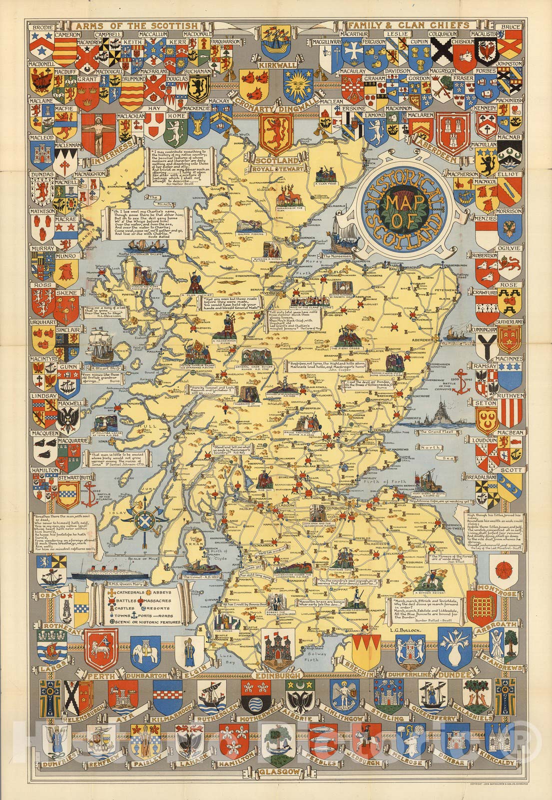
Historical Map of Scotland. By L.G. Bullock. John Bartholomew & Son Ltd. Edinburgh, 1950 - Vintage Wall Art
Historical Map of Scotland. By L.G. Bullock. John Bartholomew & Son Ltd. Edinburgh, 1950 - Vintage Wall Art
Note: Sold out or unavailable
Couldn't load pickup availability
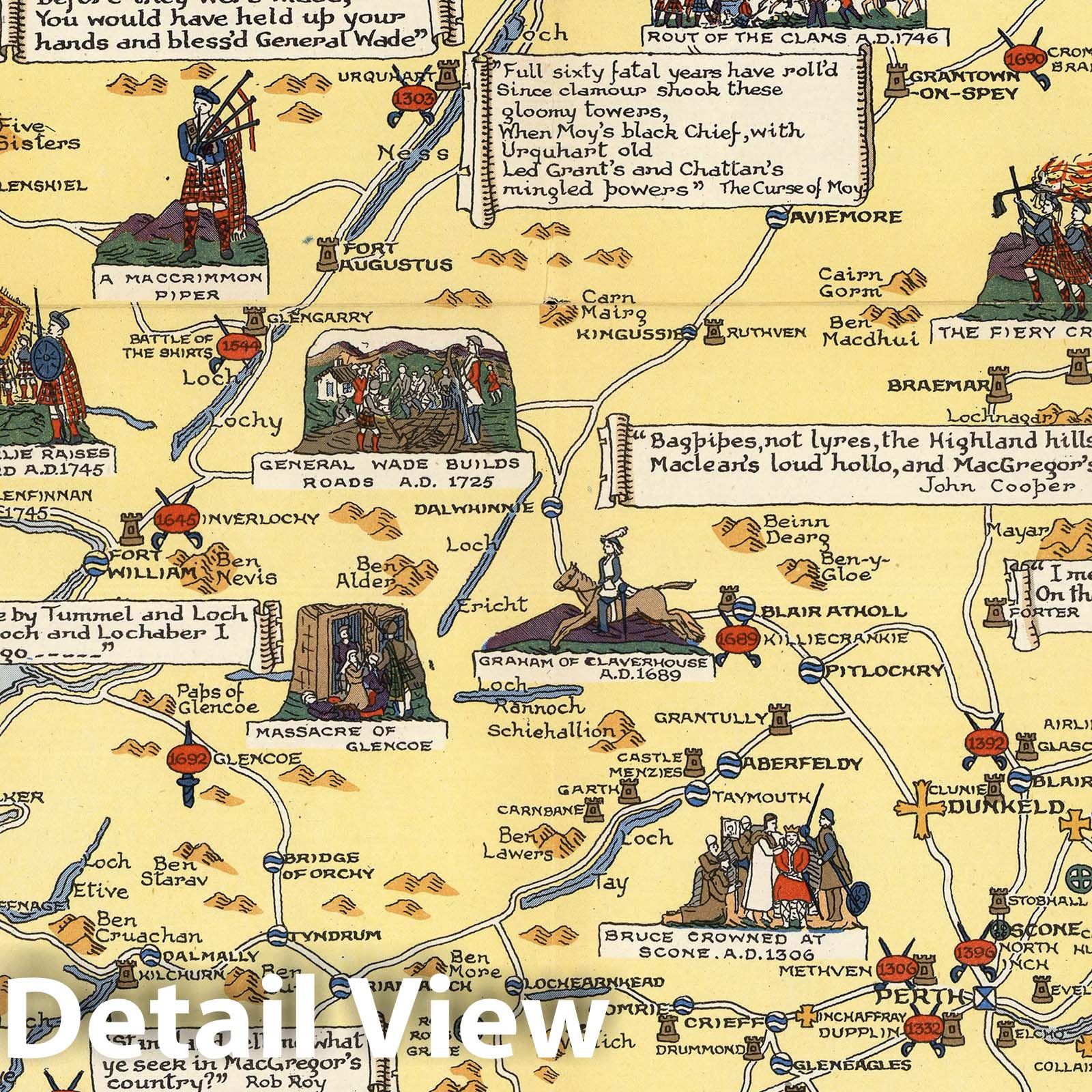
The Historical Map of Scotland by L.G. Bullock, published in 1950 by John Bartholomew & Son Ltd., is a comprehensive map that shows the historical evolution of Scotland from ancient times to the 20th century. The map has intricate details of the country's topography, highlighting the major rivers, mountains, and the coastline, with exquisite drawings of the various historical structures and castles that dot the landscape. The map also showcases the various settlements and cities, including Edinburgh and Glasgow, and important landmarks such as Loch Ness. The map is intricately designed with an ornamental cartouche and a coat of arms, adding to its aesthetic appeal.
In addition to its aesthetic appeal, the Historical Map of Scotland is also a valuable resource for historians and scholars. The map provides information on the various historical events that have shaped Scotland's history, including battles and invasions. It also highlights the important individuals who have played a significant role in Scotland's history, such as the kings and queens of Scotland. Overall, the Historical Map of Scotland provides a comprehensive and detailed overview of Scotland's rich history, making it an invaluable resource for historians, scholars, and anyone interested in the country's past.
- MUSEUM QUALITY INKS AND PAPER: Printed on thick 192gsm heavyweight matte paper with archival giclee inks, this historic fine art will decorate your wall for years to come.
- VINTAGE MAP REPRODUCTION: Add style to any room's decor with this beautiful print. Whether your interior design is modern or classic, a map is never out of fashion.
- ATTENTION TO DETAIL: We edit every antique map for image quality, color and vibrance, so it can look its best while retaining historical character. Makes a great gift!
- FRAME READY: Your unframed poster will arrive crease-free, rolled in a sturdy mailing tube. Many maps fit easy-to-find standard size frames 16x20, 16x24, 18x24, 24x30, 24x36, saving on custom framing.
- Watermarks will not appear in the printed picture. Some blemishes, tears, or stamps may be removed from the final print.
Why choose Historic Pictoric
Every artwork we offer is carefully edited by our small but dedicated team of image professionals, ensuring each detail is perfect. We print every order to demand right here in the USA, treating every piece with the same care and attention we would give our own work. From editing to printing to packaging, we take pride in delivering artwork that meets our high standards—and we love knowing it’s heading to a home where it will be appreciated.