You have no items in your shopping cart.
- Home
- Maps
-
State Maps
- Alabama
- Alaska
- Arizona
- Arkansas
- California
- Colorado
- Connecticut
- Delaware
- Florida
- Georgia
- Hawaii
- Idaho
- Illinois
- Indiana
- Iowa
- Kansas
- Kentucky
- Louisiana
- Maine
- Maryland
- Massachusetts
- Michigan
- Minnesota
- Mississippi
- Missouri
- Nebraska
- Nevada
- New Hampshire
- New Jersey
- New Mexico
- New York
- North Carolina
- North Dakota
- Ohio
- Oklahoma
- Oregon
- Pennsylvania
- Rhode Island
- South Carolina
- South Dakota
- Tennessee
- Texas
- Utah
- Vermont
- Virginia
- Washington
- West Virginia
- Wisconsin
- Wyoming
- Art Prints
- Photographs
- Contact Us
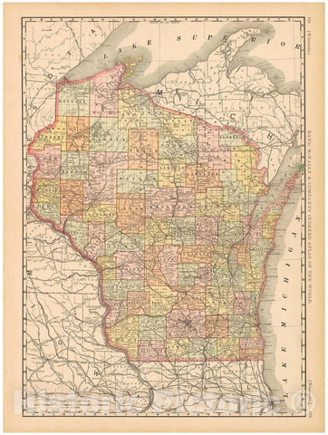
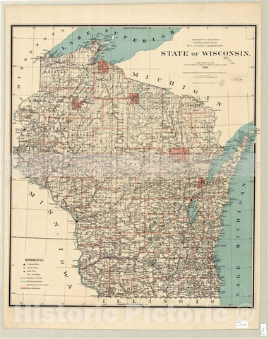
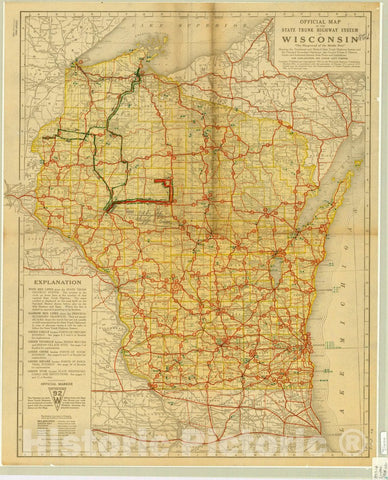
![Map : Wisconsin 1912, State of Wisconsin [map] , Antique Vintage Reproduction](http://www.historicpictoric.com/cdn/shop/products/5166352_1wmrk_large.jpg?v=1683150058)
![Map : Wisconsin 1855, Map of the State of Wisconsin shewing [sic] the location of the ancient works , Antique Vintage Reproduction](http://www.historicpictoric.com/cdn/shop/products/5161725_1wmrk_large.jpg?v=1683150270)
![Map : Wisconsin 197-?, [Outline map of the State of Wisconsin showing county boundaries and names], Antique Vintage Reproduction](http://www.historicpictoric.com/cdn/shop/products/5161270_1wmrk_large.jpg?v=1683150283)

![Map : Welcome to Potawatomi State Park, summer use map, Wisconsin , [Wisconsin state parks , forests, recreation areas & trails maps], Antique Vintage Reproduction](http://www.historicpictoric.com/cdn/shop/products/5157815_1wmrk_large.jpg?v=1683150455)
![Map : Yellowstone Lake State Park, Wisconsin , [Wisconsin state parks , forests, recreation areas & trails maps], Antique Vintage Reproduction](http://www.historicpictoric.com/cdn/shop/products/5157813_1wmrk_large.jpg?v=1683150465)
![Map : Devil's Lake State Park , Wisconsin , [Wisconsin state parks , forests, recreation areas & trails maps], Antique Vintage Reproduction](http://www.historicpictoric.com/cdn/shop/products/5157812_1wmrk_large.jpg?v=1683150464)
![Map : Hoffman Hills State Recreation Area, Wisconsin , [Wisconsin state parks , forests, recreation areas & trails maps], Antique Vintage Reproduction](http://www.historicpictoric.com/cdn/shop/products/5157809_1wmrk_large.jpg?v=1683150465)
![Map : Mirror Lake State Park, Wisconsin , [Wisconsin state parks , forests, recreation areas & trails maps], Antique Vintage Reproduction](http://www.historicpictoric.com/cdn/shop/products/5157807_1wmrk_large.jpg?v=1683150465)
![Map : Glacial Drumlin Trail - West, Wisconsin , [Wisconsin state parks , forests, recreation areas & trails maps], Antique Vintage Reproduction](http://www.historicpictoric.com/cdn/shop/products/5157799_1wmrk_large.jpg?v=1683150448)
![Map : Newport State Park, Wisconsin , [Wisconsin state parks , forests, recreation areas & trails maps], Antique Vintage Reproduction](http://www.historicpictoric.com/cdn/shop/products/5157795_1wmrk_large.jpg?v=1683150460)
![Map : Bong State Recreation Area, Wisconsin , [Wisconsin state parks , forests, recreation areas & trails maps], Antique Vintage Reproduction](http://www.historicpictoric.com/cdn/shop/products/5157790_1wmrk_large.jpg?v=1683150455)
![Map : Kettle Moraine State Forest, Southern Unit, Wisconsin , [Wisconsin state parks , forests, recreation areas & trails maps], Antique Vintage Reproduction](http://www.historicpictoric.com/cdn/shop/products/5157786_1wmrk_large.jpg?v=1683150461)
![Map : Lapham Peak, Kettle Moraine State Forest, Wisconsin , [Wisconsin state parks , forests, recreation areas & trails maps], Antique Vintage Reproduction](http://www.historicpictoric.com/cdn/shop/products/5157780_1wmrk_large.jpg?v=1683150449)
![Map : Copper Falls State Park, Wisconsin , [Wisconsin state parks , forests, recreation areas & trails maps], Antique Vintage Reproduction](http://www.historicpictoric.com/cdn/shop/products/5157779_1wmrk_large.jpg?v=1683150453)
![Map : Wildcat Mountain State Park deer hunting, Wisconsin , [Wisconsin state parks , forests, recreation areas & trails maps], Antique Vintage Reproduction](http://www.historicpictoric.com/cdn/shop/products/5157778_edit__1wmark_large.jpg?v=1683150460)
![Map : Governor Dodge State Park, Wisconsin , [Wisconsin state parks , forests, recreation areas & trails maps], Antique Vintage Reproduction](http://www.historicpictoric.com/cdn/shop/products/5157777_1wmrk_large.jpg?v=1683150460)
![Map : Badger Trail, Wisconsin , [Wisconsin state parks , forests, recreation areas & trails maps], Antique Vintage Reproduction](http://www.historicpictoric.com/cdn/shop/products/5157776_1wmrk_large.jpg?v=1683150449)
![Map : Kohler Andrae State Park, Wisconsin , [Wisconsin state parks , forests, recreation areas & trails maps], Antique Vintage Reproduction](http://www.historicpictoric.com/cdn/shop/products/5157774_1wmrk_large.jpg?v=1683150453)
![Map : Pattison State Park, Wisconsin , [Wisconsin state parks , forests, recreation areas & trails maps], Antique Vintage Reproduction](http://www.historicpictoric.com/cdn/shop/products/5157772_1wmrk_large.jpg?v=1683150462)
![Map : Brunet Island State Park, Wisconsin , [Wisconsin state parks , forests, recreation areas & trails maps], Antique Vintage Reproduction](http://www.historicpictoric.com/cdn/shop/products/5157769_1wmrk_large.jpg?v=1683150450)
![Map : Perrot State Park, Wisconsin , [Wisconsin state parks , forests, recreation areas & trails maps], Antique Vintage Reproduction](http://www.historicpictoric.com/cdn/shop/products/5157767_1wmrk_large.jpg?v=1683150467)
![Map : Kinnickinnic State Park, Wisconsin , [Wisconsin state parks , forests, recreation areas & trails maps], Antique Vintage Reproduction](http://www.historicpictoric.com/cdn/shop/products/5157763_1wmrk_large.jpg?v=1683150462)
![Map : High Cliff State Park, Wisconsin , [Wisconsin state parks , forests, recreation areas & trails maps], Antique Vintage Reproduction](http://www.historicpictoric.com/cdn/shop/products/5157760_1wmrk_large.jpg?v=1683150461)
![Map : Wyalusing State Park, Wisconsin , [Wisconsin state parks , forests, recreation areas & trails maps], Antique Vintage Reproduction](http://www.historicpictoric.com/cdn/shop/products/5157759_1wmrk_large.jpg?v=1683150450)
![Map : Lake Wissota State Park, Wisconsin , [Wisconsin state parks , forests, recreation areas & trails maps], Antique Vintage Reproduction](http://www.historicpictoric.com/cdn/shop/products/5157756_1wmrk_large.jpg?v=1683150458)
![Map : Welcome to Whitefish Dunes State Park, Wisconsin , [Wisconsin state parks , forests, recreation areas & trails maps], Antique Vintage Reproduction](http://www.historicpictoric.com/cdn/shop/products/5157754_1wmrk_large.jpg?v=1683150454)
![Map : Peninsula State Park, Wisconsin , [Wisconsin state parks , forests, recreation areas & trails maps], Antique Vintage Reproduction](http://www.historicpictoric.com/cdn/shop/products/5157755_1wmrk_large.jpg?v=1683150462)
![Map : Ice Age Trail, Chippewa Moraine Segment, Ice Age National Scientific Reserve, Wisconsin , [Wisconsin state parks , forests, recreation areas & trails maps]](http://www.historicpictoric.com/cdn/shop/products/5157753_1wmrk_large.jpg?v=1683150450)
![Map : Welcome to Hartman Creek State Park, summer use , Wisconsin , [Wisconsin state parks , forests, recreation areas & trails maps], Antique Vintage Reproduction](http://www.historicpictoric.com/cdn/shop/products/5157751_1wmrk_large.jpg?v=1683150470)
![Map : Kettle Moraine State Forest, Northern Unit, designated trails and public use areas, Wisconsin , [Wisconsin state parks , forests, recreation areas & trails maps]](http://www.historicpictoric.com/cdn/shop/products/5157749_1wmrk_large.jpg?v=1683150450)
![Map : Roche-A-Cri State Park, Wisconsin , [Wisconsin state parks , forests, recreation areas & trails maps], Antique Vintage Reproduction](http://www.historicpictoric.com/cdn/shop/products/5157744_1wmrk_large.jpg?v=1683150468)
![Map : Old Abe State Trail, Wisconsin , [Wisconsin state parks , forests, recreation areas & trails maps], Antique Vintage Reproduction](http://www.historicpictoric.com/cdn/shop/products/5157742_1wmrk_large.jpg?v=1683150469)
![Map : Willow River State Park, Wisconsin , [Wisconsin state parks , forests, recreation areas & trails maps], Antique Vintage Reproduction](http://www.historicpictoric.com/cdn/shop/products/5157739_1wmrk_large.jpg?v=1683150458)
![Map : Wisconsin Date unknown, [Wisconsin state parks , forests, recreation areas & trails maps]. |"400|" State Trail, Wisconsin , Antique Vintage Reproduction](http://www.historicpictoric.com/cdn/shop/products/5157737_1wmrk_large.jpg?v=1683150462)
![Map : Northern Highland - American Legion State Forest, Wisconsin , [Wisconsin state parks , forests, recreation areas & trails maps], Antique Vintage Reproduction](http://www.historicpictoric.com/cdn/shop/products/5157736_1wmrk_large.jpg?v=1683150454)
![Map : Governor Nelson State Park, Summer use map, Wisconsin , [Wisconsin state parks , forests, recreation areas & trails maps], Antique Vintage Reproduction](http://www.historicpictoric.com/cdn/shop/products/5157732_1wmrk_large.jpg?v=1683150451)
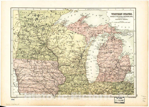
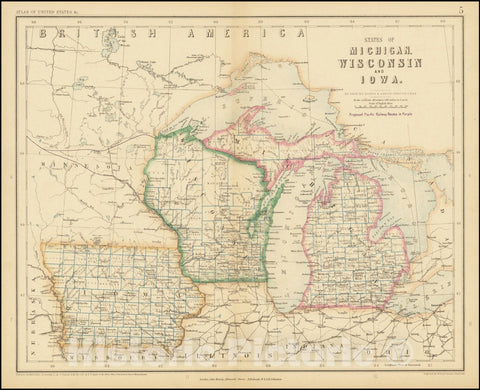
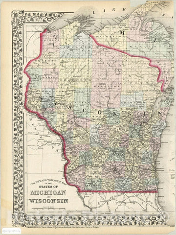
![Historic Map : 1874 Reference Map of the United States Section No. 9 [Wisconsin & Michigan] : Vintage Wall Art](http://www.historicpictoric.com/cdn/shop/products/5116898_wmark_large.jpg?v=1683153983)